PARIS: A member of the French navy using an app to track his jogging performance has broadcast the exact location of his country’s flagship aircraft carrier, a newspaper reported.
France deployed the Charles de Gaulle – and accompanying frigates – to the Mediterranean in early March, shortly after US-Israeli strikes on Iran sparked war in the Middle East.
It has been present in the Eastern Mediterranean since March 9 as part of what Emmanuel Macron described as a “purely defensive” posture of support for France’s allies in the conflict.
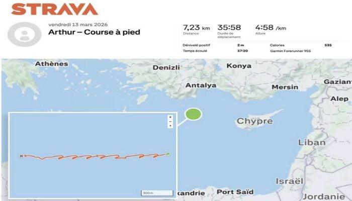
The World The newspaper reported on Thursday that the runner ran in circles on a moving ship on March 13 in the middle of the sea northwest of Cyprus, according to his public profile on fitness tracking app Strava, while satellite images showed the aircraft carrier was in the immediate vicinity at the time.
The same person also ran in Copenhagen, Denmark, in late February, on a bridge coming from Malmö, Sweden, where the Charles de Gaulle was anchored at the time, according to Strava data.
The French armed forces declared AFP Appropriate action would be taken if the report was true, as members of the navy were regularly reminded of the risk of security breaches when using such applications.
“The reported case – if confirmed – is not consistent with current guidance,” the statement said.
Running application profiles has already leaked sensitive information.
In 2024, The World reported that bodyguards for Macron, U.S. President Joe Biden and Russian leader Vladimir Putin inadvertently leaked information about their whereabouts while accompanying them on a trip.
In 2018, Strava maps showed the locations of U.S. and allied military personnel in Iraq, Syria, and Afghanistan.
Although some bases were well known to groups likely to want to attack them, the maps also showed what appeared to be the routes taken by forces moving outside the bases — information that could have been used to plan bombings or ambushes.