
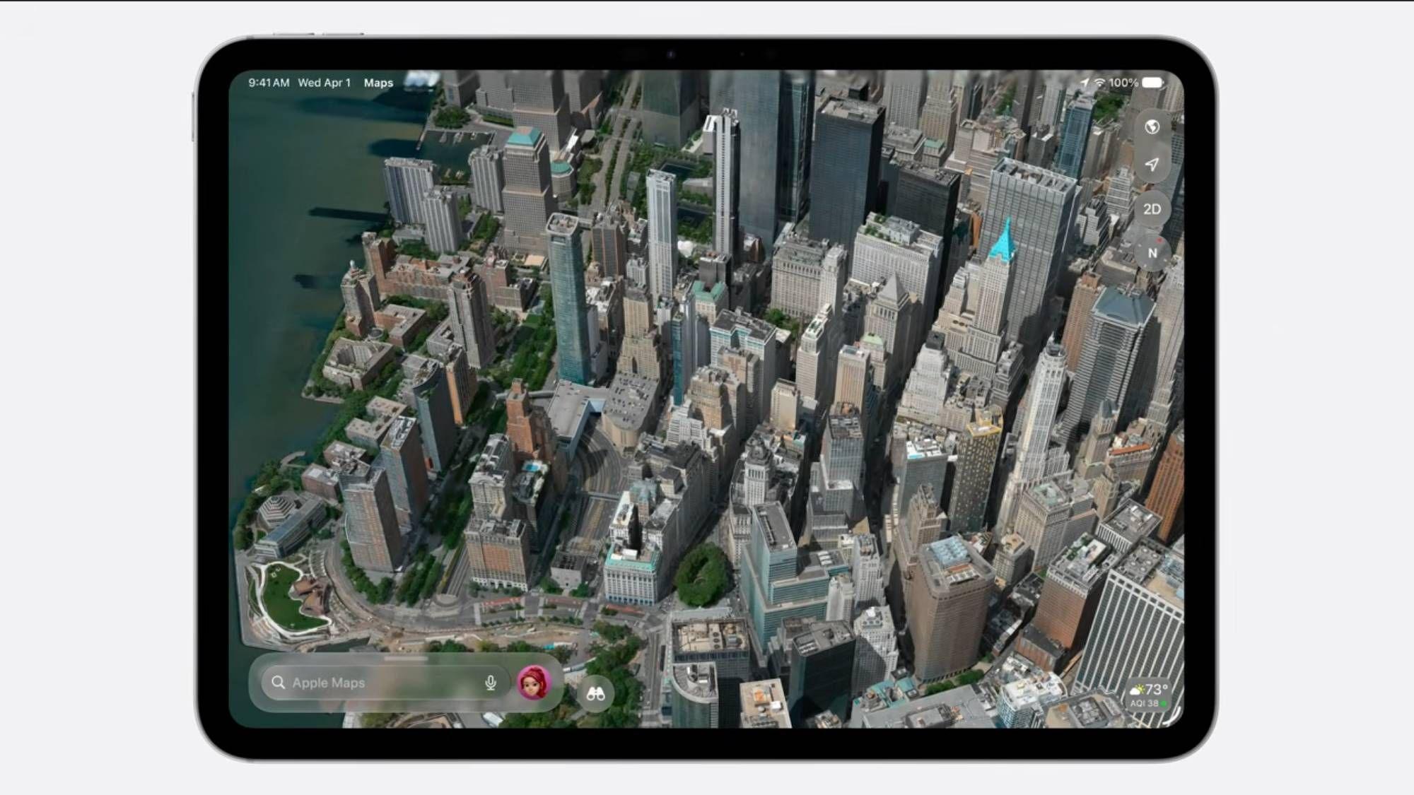
- Apple Maps gets a huge visual upgrade from Flyover
- It will use Vision Intelligence and aerial imagery to create detailed 3D models of cityscapes.
- It appears that Apple has also adopted Gaussian Splatting to make its 3D models easier to render.
Apple’s upcoming iOS 27 upgrade isn’t just about fancy new AI upgrades like the new Siri voice assistant, but Apple Maps is also getting a pretty notable overhaul.
During its WWDC 2026 keynote, Apple took a moment to highlight the new visual upgrade to the Flyover tool in Apple Maps, which lets you view more than 350 cities around the world in 3D from a bird’s eye view. In iOS 27, Flyover will display both buildings and natural landscapes using a combination of aerial imagery and Apple’s Vision Intelligence models to produce even more detailed 3D views.
Although Apple didn’t go into detail, the images used in the The WWDC presentation suggests that the company has also adopted Gaussian Splatting to create its 3D landscapes, a graphics technique that uses video footage as the basis for creating a 3D frame. This tool could really give Apple a huge advantage over Google Maps, which still uses photogrammetry to generate its own 3D models.

This is not a theory that is completely out of the question; some users also pointed this out after seeing the newly rendered images in Apple’s keynote (see below).
holy shit! Apple just beat Google to the punch – 3D Gaussian splashes are coming to Apple Maps. These 3D scenes are created from oblique aerial images. but unlike blobby photogrammetry – no more broccoli, no more melted power lines – ground level details that actually hold up… pic.twitter.com/Iv95I3yfbjJune 8, 2026
Flyover’s enhanced images are designed to bring out every visual aspect of Apple Map’s 3D aerial views, including essential details that go unnoticed. Speaking at WWDC, OS Vice President of Program Management Stacey Ford said: “From the beautiful architectural details to the shapes of individual trees to the way light reflects off the windows of skyscrapers, you’ll see cities around the world like never before.”
The update is a pretty big technical change for Apple Maps and will join other upgrades from macOS Golden Gate to custom AirPods EQ adjustments in iOS 27. The only downside is that you’ll have to wait a bit to test Flyover’s new look, as iOS 27 is expected to roll out publicly in September – but you can sign up as a developer and download the first beta of iOS 27 now.
Although there are still a few months to wait, users have spotted signs that Apple is tinkering with Flyover ahead of the wider iOS 27 rollout.

When the announcement was shared with the r/AppleMaps community on Reddit, users flocked to the comments to share more theories. One user believes Apple is conducting a “weird rollout,” claiming that the move to iOS 27 reverts previously supported cities to poor quality satellite imagery, while newly supported cities receive the visual upgrade.
Based on user experience, they recall seeing a handful of U.S. locations, including San Antonio, Houston, Dallas, and Phoenix, return to 2D, as well as international cities such as Sydney, Paris, and Stockholm. In contrast, Vegas, London, Berlin, Barcelona and others have been modernized.
For now, it’s still a guessing game, and Apple likely won’t provide more information until we get closer to the wider launch of iOS 27 later this year. That said, Apple’s move from photogrammetry to Gaussian Splatting marks a big change in digital map rendering, and we’re now waiting for Google Maps to follow suit.

Follow TechRadar on Google News And add us as your favorite source to get our news, reviews and expert opinions in your feeds.